Geology news: Discovery of Zealandia-Is it the 8th continent?

As we know, Earth has a thin outer layer called crust that is broken into several plates called
lithospheric or tectonic plates. Continents are the demarcations on these plates recognised by
humans for their convenience. Geologists and geographers don’t entirely agree on what
actually makes a continent: for a geographer, Europe and Asia are two separate entities, while
geologists lump them together as ‘Eurasia’. By convention, our planet has seven continents,
but there’s no international body or committee that decrees which landmasses of the Earth’s
crust should be defined as such. This is what researchers are currently proposing.
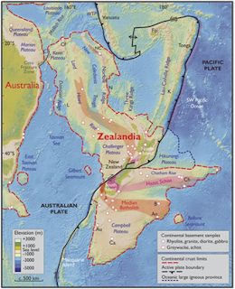
According to their latest analysis, Zealandia is a 4.9 million-square- kilometre expanse of
continental crust that’s 94% underwater, with only New Zealand and New Caledonia sitting
above the ocean surface. Researchers have been gathering data on this continental crust for
the past 10 years to formally put forward a scientific case for the continent of Zealandia.
However, this does not make New Zealand an island continent. The two islands are simply
the highest points of Zealandia, with earthquakes in the region governed by the intersection
of the Australian and Pacific tectonic plates. Previously, it was thought that the crust
underneath the ocean in this area was fragmented into various bits. But according to new
satellite-based gravity maps of the ancient seafloor, it is now clear that the whole region is
continuous whole.
Source
http://www.nationalgeographic.com.au/nature/is-zealandia-really-the-8th-continent.aspx
Compiled by Suman Matha

Comments
Post a Comment