The East African Rift System (EARS)
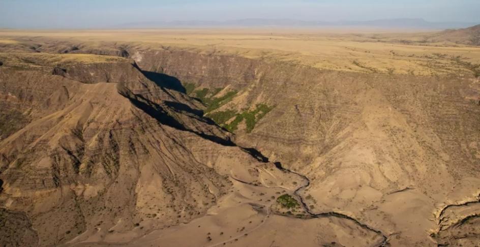 |
| A bird's eye view of a gorge in the East African Rift at Engaruka, Tanzania. |
The East African Rift system is a geological wonder of the earth. At which the two plates are constantly in motion and trying to split apart. Along the rift, a new continent is breaking away from the larger African landmass, this will give rise to the new ocean in the world.
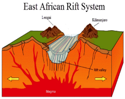 |
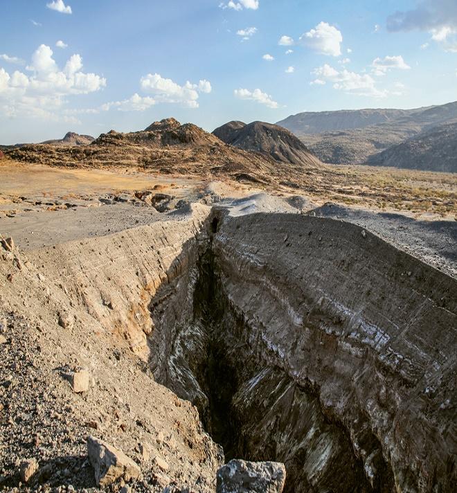
| The formation of mountains along the Rift at Tanzania |
A Rift is a fracture on the earth’s surface that widens over time as an elongate basin bounded by opposed steeply dipping normal faults. The best example of Rift is an East African system that we are experiencing for the past 30 Ma years.
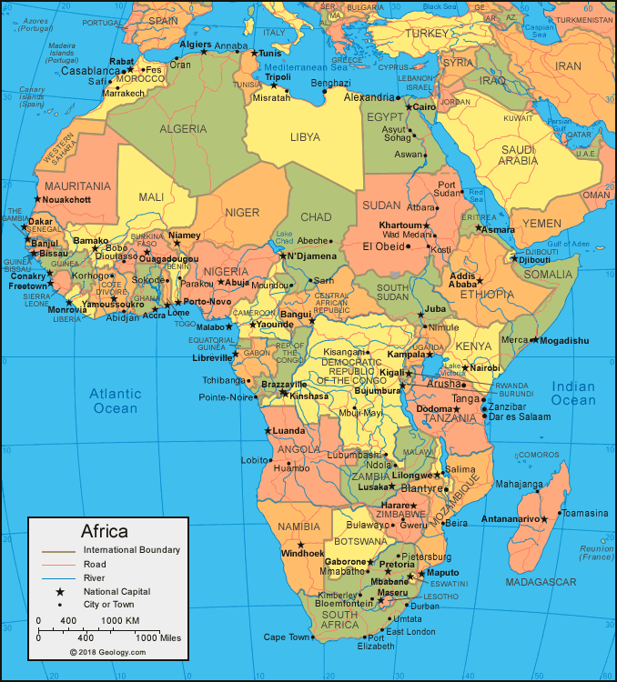 |
| The political map of Africa showing countries |
The countries in the African continent are Algeria, Angola, Benin, Botswana, Burkina Faso, Burundi, Cabo Verde ,Cameroon, Central African Republic ,Chad, Comoros, Congo, Democratic Republic of the Congo, Republic of the Cote d'Ivoire, Djibouti, Egypt, Equatorial Guinea, Eritrea, Eswatini ,Ethiopia, Gabon, Gambia ,Ghana, Guinea, Guinea-Bissau, Kenya, Lesotho, Liberia, Libya, Madagascar, Malawi, Mali, Mauritania, Mauritius, Morocco, Mozambique, Namibia, Niger, Nigeria, Rwanda, Sao Tome and Principe, Senegal, Seychelles, Sierra Leone, Somalia, South Africa, South Sudan, Sudan, Tanzania, Togo, Tunisia, Uganda, Zambia, Zimbabwe.
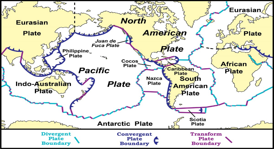 |
| World map showing different plates on earth with the type of boundary |
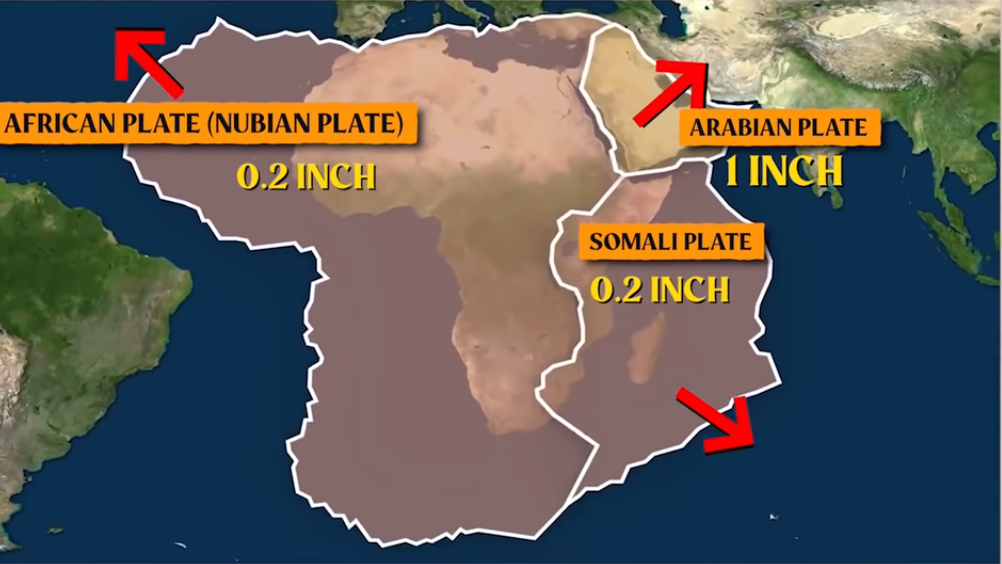
The cause of rifting is plate tectonics where each plate moves 1-2 inches in a year. There are three types of plate boundaries convergent, divergent and transform. In convergent plate boundaries the plate moves away from each other. In divergent plate boundaries plates move against each other. In transform plate boundaries the two plates slide past each other horizontally.
 |
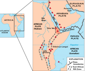
| A map of East Africa showing somme of the historically active volcanoes (as red triangles) and the Afar Triangle (Shaded at the center). |
The East African Rift is an active continental rift zone in East Africa. The EAR began developing around the onset of the Miocene 22-25 million years ago. In the past, it was considered to be part of the larger Great Rift Valley that extended north to Asia Minor. The Rift is a narrow zone that is developing divergent tectonic plate boundary, in which the African plate is the process of splitting into tectonic plate boundary called the Somali plate and in the Nubian plate at a rate of 6-7 mm annually. As extension continues lithospheric rupture will occur within 10 million years; the Somalian Plate will break off and a new Ocean basin will fan orm orent a series of distinct rift basins the East African Rift system extends over thousands of kilometers. the EAR consists of two main branches the East African Valley includes the Main Ethiopian Rift, running eastwards from the Afar Triple Junction, which continues south as the Kenyan Rift Valley. The Western Rift Valley includes the Albertine Rift and farther south the valley of Lake Malawi. To the north of the Afar Triple Junction the Rift follows one of two Paths west to the Red Sea Rift or east to the Aden Ridge in the Gulf of Aden the EAR runs from the Afar Triple Junction in the Afar depression of Ethiopia through Eastern Africa, terminating in Mozambique the EAR transects through Ethiopia, Kenya, Uganda, Rwanda, Burundi, Zambia, Tanzania, Malawi and Mozambique. It also runs offshore the Mozambique along the kerimba and lacerda garbens which are joined by the Davie Ridge a 2200 km-long relic fracture zone that cuts across the West Somali Basin, straddling the boundary between Tanzania and Mozambique.
The Davie Ridge ranges between 30-120 Km wide, with a west facing scarp along the southern half of its length that rises to 2300m above the sea floor. Its movement is concurrent with the year completing theories on geological evolution over time many theories have tried to clarify the evolution of the East African Rift. In 1972 it was proposed the EAR was not caused by tectonic activity, but rather by differences in crustal density. Others proposed an African superplume causing mantle deformation. However the Varying geochemical signatures of a suite of Ethiopian lavas suggests multiple plume sources at least one of deep mantle origin and one form within the subcontinental lithosphere additionally, the subject of deep-rooted mantle plumes is still a matter of controversy and therefore cannot be confirmed. The most recent and accepted view is the theory put forth in 2009. that magmatism and plate tectonics have a feedback with one another, controlled by oblique critical conditions. At that time it was suggested that lithosphere thinning generated volcanic activity, further increasing the magmatic processes at play such as intrusions and numerous small plumes. These processes further thin the lithosphere in concentrated areas, forcing the thinning of the lithosphere to behave like a mid oceanic ridge. Geology evolution prior to rifting enormous Continental flood basalts erupted on the surface and uplift of the Ethiopian Somalian and East African plateaus occurred. The first stage of rifting of the EAR is characterized by the rift localization and Magnetism along the entire rift zone. Periods of extension alternated with Times of relative inactivity. There was also the reactivation of a Pre-Cambrian weakness in the crust a suture zone of multiple cratons, displacement along large boundary faults and the development of the asymmetric basins. The second stage of rifting is characterized by the deactivation of large boundary faults the development of internal fault segments, and the concentration of magmatic activity towards the rift segment of the East African Rift system from zones of localized strain these rifts are the result of the actions of numerous normal faults which are typically for all tectonic rift zones. As fore mentioned, voluminous magnetism and Continental flood basalts characterize some of the rift segment as the Western branch. have only very small volumes of volcanic the African Continental crust generally cool and strong. Many cratons are found throughout the EAR such as Tanzania and kaapvaal cratons are thick and survived for billions of years with little tectonic activity. They are characterized by greenstone belts, tonalities, and other high-grade Metamorphic lithologies. The craton is of significant importance in terms of mineral resources with major deposits of gold antimony, iron, chromium, and Nickel. A large volume of Continental flood basalt erupted during the Oligocene with the majority of the volcanism coinciding with the opening of the Red Sea and the Gulf of Aden approximately 30 million years ago. The composition of the volca arenic of Continuum of ultra-alkaline to the doleritic and felsic rocks. It has been suggested that the diversity of the composition could be partially explained by different mantle source regions.
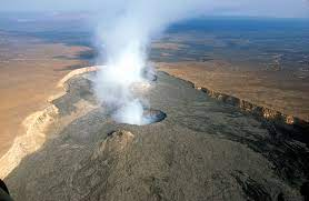
The EAR also cuts through old sedimentary rock deposited in ancient basins of active as well as dormant volcanoes among them. mount Kilimanjaro, mount Kenya, mount Longonot, Menegai crater, mount Karisimbi, mount Nyiragongo, mount Meru and mount Elgon as well as the crater highlands in Tanzania although most of these mountains lie outside of the rift Valley, the EAR created them. Active volcanoes include Erta Ale, Dalla Filla and Ol Doinyo lengai, the former of which is a continuously active basaltic Shield volcano in the Afar region of North-Eastern Ethiopia. when Dalla Filla and Ol Doingo lengai the former of which is a continuously active basaltic shield volcano in the Afar region of northeastern Ethiopia. when Dalla Filla erupted in 2008 it was the largest volcanic eruption in Ethiopiain recorded history. The Ol Doinyo lengai volcano is currently the only active natrocarbonatite volcano in the world. The magma contains almost no silca, making flow viscosity extremely low. its Lava fountain crystallize in mid-air then shatter like glass. According to National Geographic approximately 50 volcanic structures in Ethiopia alone have documented activity since the onset holocene. the EAR is the largest seismically active Rift system on earth today. The majority of earthquakes occur near the Afar depression with the largest earthquakes typically occuring along or near major border faults. Seismic events in the past century are estimated to have reached a maximum moment magnitude of 7.0 richter scale. The East African Rift tells us that how continents break apart and also if movement continues it can give rise to new ocean and a new continent to the earth.
By
Yash Santosh Bagkar
SY Geology
Citation
Kruger National Park Standard safari: Itineraries. (n.d.). Retrieved April 3, 2022, from https://safari-index.com/wp-content/uploads/2017/06/Kruger-National-Park-Standard-Safari-Itineraries.pdf
Pulsedive. (n.d.). Threat intelligence. Pulsedive. Retrieved April 3, 2022, from https://pulsedive.com/ioc/cdn.mos.cms.futurecdn.net
U.S. Department of the Interior. (n.d.). Tropical storms. National Parks Service. Retrieved April 3, 2022, from https://www.nps.gov/subjects/geology/tropical-storms.htm
Commons:upload. Wikimedia Commons. (n.d.). Retrieved April 3, 2022, from https://commons.wikimedia.org/wiki/Commons:Upload
YouTube. (2021, April 9). Like Sher and Cammen thttps://youtu.be/ux_vkgNmcDE. YouTube. Retrieved April 3, 2022, from https://www.youtube.com/watch?v=ogk4jJ_qCQw
File:ERTA Ale.jpg - Wikimedia Commons. (n.d.). Retrieved April 3, 2022, from https://commons.wikimedia.org/wiki/File:Erta_Ale.jpg

Comments
Post a Comment