Landslides in Sadda area
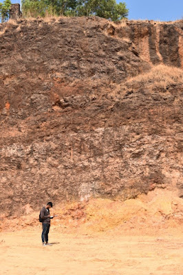
Our project titled “Landslides in Sadda area” in Vasco is about studying the landslides occurring within the area and also about finding the factors which are triggering these landslides. We are also going to prepare a landslide prone map for that region demarcating the landslide areas with the help of applications such as “Google Earth Pro” and “Q-GIS” and also all the houses which are affected due to the landslides. We had conducted a survey in which we had noted all the houses who had received the evacuation notices and we also as to what are the measures that they take when such landslides occur within the area. From the Google earth images and also some the gravelly laterite flow exposed at the bottom we have concluded that an ancient landslide had occurred within the area due to which benches are formed. The people have built their houses on these benches due to which landslides are getting triggered within the region. Due to undercutting of the laterite in this region for various construction purposes the inner portion is getting eroded which intern leads to landslides. The unlined drainage and also fluctuating water table within the region is also responsible for the landslides within the area. We have also found a basement rock for the area which is a Meta-basalt which is exposed at the bottom.
Contributor: Johnny Rodrigues


Comments
Post a Comment